

For years now I have been wanting to drive out to
Neah Bay and
Cape Flattery, and after my recently trip to the
end of Hwy. 109 I was even more determined to finally make the trip. Since I had some time off this week I decided to not only drive out to Cape Flattery, but also drive Hwy. 101 as far around the Olympic Peninsula as I could in a single day. Even though it turned out to be a long day I had a blast!
I was originally going to take the trip on Monday, but held off until Tuesday due to a storm that came through the area and from the looks of things I made the right call. I left Bellevue just before 5:00 AM and headed South to Tacoma where I would head over the Tacoma Narrows bridge to Sequim and to Neah Bay and Cape Flattery for the first leg of the trip. Click this link to see the
map of the first leg of my trip.
I had originally intended to drive all of Hwy. 112 from
Port Angeles to Neah Bay, but when I stopped in
Sequim at just after 7:00 AM to top off my tank and told the clerk at the station about my trip they advised me that it would be best to take an alternate route. Apparently Hwy. 112 has a lot more twists and turns than is shown on the maps, and given the time of year and recent storm it would turn out to be a very long drive. The clerk suggested that I continue on Hwy 101 to
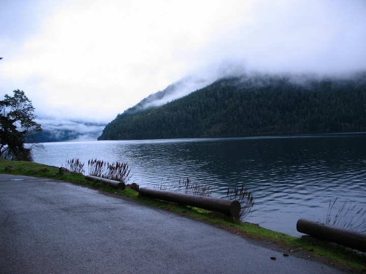
Sappho WA, and then turn off on to Hwy. 113 and head North until Hwy. 113 intersected with Hwy. 112 and then continue on Hwy 112 to Neah Bay. Even though this route is 10 miles longer than my original route, according to the clerk and others I spoke to later, it is actually is a half hour shorter then my original route is on a good day. Besides saving time another plus to this route is I that I ended up driving along the Southern shore of
Lake Crescent which as absolutely beautiful in the early morning light with the fog wisping all around.
Along the way I stopped off at a vantage point in Port Angeles to take the first pictures of the trip. Unfortunately I was still in the AM fog when I snapped those shots, so there is only one decent picture of Port Angeles in my
Picasa Web Album. I was out of the mental fog and in to the real fog when I took the pictures at Lake Crescent, so those turned out a little better than the first shot.
I reached Neah bay around 9:45 which is actually good time when you consider the stops I made along Lake Crescent to take pictures. When entering Neah Bay I noticed a sign stating that visitors must obtain a
Recreational Use Permit when entering the
Makah Nation, so I stopped at the
Makah Mini Mart and picked one up for $10.00. The permit is good for an entire year, and fees helps maintain the roads and trails used for recreational purposes. I am going to hold on to my permit just in case I decide to visit Neah Bay again this year, and maybe then I will drive all of Hwy. 112. Just a note to all of you using Google Maps, the address on the Makah Mini Mart web site is listed as 931
Bay View Ave., Neah Bay, WA., yet Google maps lists it as 931
Holden Creek Ave., Neah Bay, WA. Go figure?
I drove the six or seven miles from Neah Bay out to Cape Flattery at a leisurely pace. Once I reached the end of the road I parked my truck and walked about a half mile or so to the Cape. The
trail is a mix of gravel or dirt (mud on this day), and boardwalks. While I didn't have any trouble with it, the sign at the beginning of the trail does note that it is moderately exerting, and if I were to do it again I would wear something other than my tennis shoes and maybe even bring a walking stick.
The only other people out at the Cape at the time were a young couple who were busy taking pictures, and I passed them along the way to the observation point. When I reached the observation point I was just blown away with the view, and went crazy taking pictures of the sea stacks, wind swept trees, and the Cape Flattery Lighthouse on Tatoosh Island. About half way through my photo frenzy it dawned on me that I was the only person at the Northwestern-most point in the contiguous United States. Wow!, that can really twist your mental nipple if you think about.
For about 15 to 20 minutes I was all alone, just taking in the scenic beauty and snapping photos with my Canon A630 . Take a look at my
web album to experience my photo frenzy, and when you do take in to account those are only half the pictures I took. I don't profess to be even a marginally good photographer, but I had a blast taking the photos and I hope that you enjoy the few good ones I took. I believe anyone with a camera would have a great time at the Cape, so bring lots of film, or if you have gone digital then bring lots of batteries and memory cards.
After I soaked in enough scenery, and rain, I headed back up the trail to my truck to start the
second leg of my trip (click for map). Heading back up the trail I passed the young couple and told them they just had to go to the observation point. I think they heeded my advise because I looked back and they were headed that way.
I got in my truck and headed back towards Neah Bay where I took a few photos, and then on to parts unknown (at least for me). While retracing my route back on Hwy. 112 to Hwy. 113, and finally to Hwy.101, I stopped at a vantage point in
Sekiu to take some more snap shots, and then continued up the road a couple of miles and stopped at another gas station in
Clallam Bay to top off my tank. It was Noon and at this point in my trip I had driven 269 miles. While paying for my gas I started up a conversation about my trip with the clerk. It turns out that the clerk, Sandi, is a wealth of information and she gladly offered up a bag full of brochures about the area as well as a lot of good information. If you ever find yourself driving Hwy. 112 to or from Neah Bay and need some gas then stop by the
Clallam Bay Shell, and strike up a conversation with Sandi and get all the free maps and brochures you need to enjoy your trip.
With a bag full of goodies including a Diet Coke and some munchies I continued on my away towards
Forks. I had intended to stop off in Forks for lunch, but Sandi told me about a great place to eat farther down the road. Since I had some munchies to tide me over for a bit I drove through Forks without even stopping to gawk at the Twilight This, and the Twilight That. Maybe some day I will come back to Forks and take a look around. There actually does seem to be a lot of stuff to take in, so if you have the time park your car at Forks and take a look around.
After about another hour I ended up near where Sandi said there would be a restaurant and store, and though she couldn't remember the name, I believe she was referring to the
Kalalock Lodge which is where I stopped and had an excellent meal. It was off-season so there weren't many people at the lodge, and this made the stop even more relaxing for me. I had the Fish and Chips, which was really good. The fish was prepared in big chunks, with a very light breading (panko I think), and the fries (chips for you traditionalists) and slaw were good too. After my meal I walked around and took some pictures of the creek running past the lodge, and of the shoreline. If I ever needed a place to get away for a while, the Kalalock Lodge is going to be my destination, especially in the off-season.
I left the Kalalock area at 2:15 PM and headed South on Hwy. 101 to
Hoquiam. The trip to Hoquiam seemed a little lackluster when compared to the trip out to Cape Flattery. This is in part due to the fact that rest of the trip Hwy. 101 went inland and not along the coast so the scenery got a little boring. The scenery was nice when Hwy. 101 skirted the Olympic National Park, but if I had it to do over again, and I had more time, I would take
Copalis Crossing Road to Copalis Beach and then head South on Hwy 109 to Ocean Shores before heading to Hoquiam.
I hit Hoquiam at 4:00 PM and topped off my truck once again. It was here that took a moment or two and thought about the next leg of my journey. Do I head South on Hwy. 101 to Long Beach and then head home, or do bag it and I head home now so I get in at a somewhat decent time? At this point I had driven 402 miles in just over 11 hours. If I drove to Long Beach I would get there after dark, and there really wouldn't be much to see (just my opinion). Given that logic I decided to end the expedition and head home, but I was going make a little detour along the way.
So off I went towards
Olympia, and then to
Enumclaw to have dinner at one of my favorite restaurants;
T-Bonz Steak and Prime Rib House. The only glitch I had with the the "detour" was that I got a little lost in downtown
Puyallup, and in the process of trying to get to Hwy 410 and then to Enumclaw, I became so distracted by an unmarked police car pulling out of a parking lot with no lights on and almost hitting me that I found myself out in the middle of an intersection on a red light. (I think the car belonged to the
WSP, but I am not sure.) Any ways, there I was in the middle of an intersection on a red light, and with no where else to go I just continued on through hoping that one of Puyallip's infamous traffic cameras wouldn't snap a photo of my truck. I didn't see a flash from a camera, but when I took a look in my rear view mirror I did see a Puyallup police car two cars behind me in the next lane over and I thought I was had. To my surprise the police car just pulled over, parked and turned off their lights. Next time I take a detour I will plan ahead and make sure I know my Highway or Freeway destinations ahead of time, so don't end up getting lost in a town I am not all that familiar with.
Eventually I made my way to Hwy. 410, and got to T-Bonz around 6:30. Gary and Sarina were fantastic hosts as always, and the meal was perfect. After a great meal and some chatting with Gary and Sarina I headed home finally making it back to my starting point at 8:30 PM. All-in-all I drove 553 miles in 15.5 hours. Not a badroad trip in my opinion.
If I were to do it again though I would definitely take more than one day. It might be nice to get hotel room in Port Angeles and head up to Victoria BC for a day. Port Angeles is in a good location to use as a base of operations while seeing the general area including Neah Bay and Cape Flattery, along with Lake Crescent. There is plenty to do there and it would be worth spending a day there just to see the town. After Port Angeles I would either stay at in Forks, or at the Kalalock Lodge. From there I would head down to
Long Beach, or even
Astoria, OR to see some more sites.
Well that's it, my big road trip to Cape Flattery, and around the Olympic Peninsula on Hwy 101. Below are the links for each leg of the trip, and to my web album:
Coincidently, after trimming down all the photos I took I ended up with 101 photos in the web album for this trip. Sort of fitting for a trip on Hwy 101 huh? Hope you enjoyed this post and feel free to leave a comment if you want.
Cheers ~ Jim Cox


